

By First Lieutenant Max Steinbach and First Lieutenant Collin Bergstrom, United States Marine Corps
First Lieutenant Max Steinbach is a Marine infantry officer serving as the company executive officer for Echo Company, 2d Battalion, 4th Marines. First Lieutenant Collin Bergstrom is a Marine infantry officer and a rifle platoon commander in the same company. The two of them built Scheme O, a planning tool for small-unit leaders, and they disclose that interest at the end of this article.
Abstract
Over the past two years the United States and its allies have pushed artificial intelligence into the planning and targeting work of combatant commands and alliance headquarters. Four echelons down, in the company office where plans become action, most leaders are still working with tools that were never built for the job. This article argues that what slows planning at that level is not a shortage of decision making but hours of mechanical labor.
To set the scene, it is late in the company office the night before an order is due. One platoon commander has a map, a protractor, and a fine-tip pen. Another is losing in a battle with a general-purpose mapping website, like CalTopo. A third is rebuilding the same concept-of-operations slide for the third time tonight, because the scheme of maneuver has changed again and the screenshot on slide four is now wrong.
Elsewhere in the same profession, planning looks nothing like that. In 2025 the Marine Corps licensed Palantir’s Maven Smart System for the entire service. NATO fielded its own variant across Allied Command Operations and declared it fully operational in June 2026. During Operation Epic Fury in March 2026, the commander of United States (US) Central Command, Admiral Brad Cooper, told reporters that advanced artificial intelligence tools were turning work that once took “hours and sometimes even days into seconds.” In January 2026 the Department of War (DOW) directed the services to become an “AI-first” force, front to back.
None of this investment is misplaced, nor should advanced capabilities be distributed evenly across every echelon. But at the bottom of the curve, the problem is not simply a smaller version of the one facing higher headquarters; it is a different problem altogether. Company and platoon commanders do not need artificial intelligence to choose a support-by-fire position. They need the repetitive mechanics of planning to stop consuming the time that they should be giving back to theirplatoons—and, most importantly, to the Staff NCOs, NCOs, and junior Marines and soldiers responsible for carrying out the plan.
The Friction Tax
The one-third, two-thirds rule is meant to protect preparation time: leaders use no more than one-third of the time available to develop the plan and leave the rest to those responsible for executing it. That time is taken from the platoon receiving the order late, the squad leader who must translate it into action, and the Marines left with fewer hours to rehearse, inspect their equipment, understand their roles, and prepare for the mission ahead.
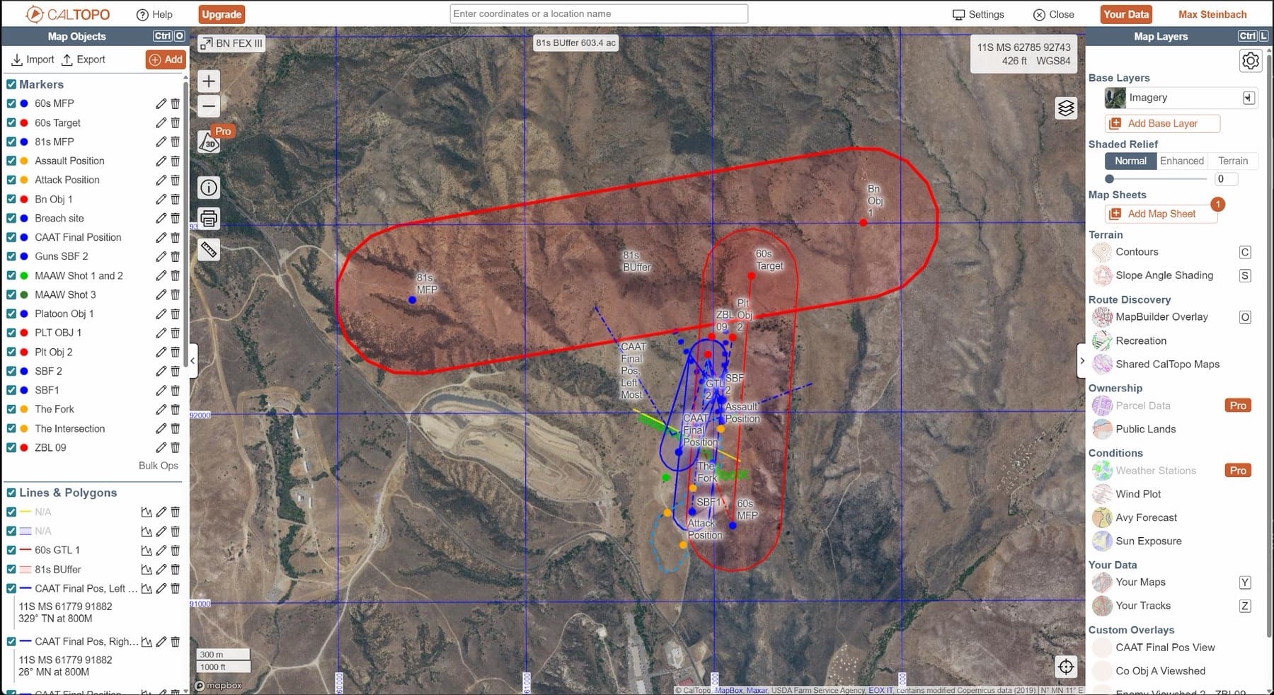
At the company and platoon level, that time is rarely lost because the tactical problem is unusually difficult. It is lost due to mechanics. Building a scheme of maneuver by hand or in general-purpose software requires plotting dozens of grid coordinates, calculating grid and magnetic azimuths, accounting for declination, tracing weapon ranges and lines of sight, and drawing the battlespace geometries that keep supporting fires away from friendly forces. Then the plan changes—as plans always do—and much of that work must be repeated. One of our own planning sessions consumed nearly eight hours across two days in a general-purpose mapping tool. The result, shown below, was an overlay that was harder to brief than the plan it was trying to convey.
Figure 1. A company plan built over two days in a general-purpose mapping platform. Every marker, line, and polygon was placed and labeled by hand. Authors’ screenshot.
That is not a skill problem. Small-unit leaders analyze a mission, read terrain, and turn intent into action, and they are good at it. The friction lives in the tooling.
Learn It by Hand First
None of this is an argument against analog planning, and we want to be blunt about that before going further. Map pens, protractors, compasses, and acetate are not quaint traditions. They are fundamentals. A leader who cannot read a map, plot a grid, shoot an azimuth, account for declination, and build an overlay by hand has no business using software that does those things for him, because he cannot tell when the output is wrong and he cannot function when the battery dies, the screen cracks, or the network drops. Degraded operations are not a thought experiment, and a fallback only works if somebody trained it.
The comparison we keep coming back to is basic math and the calculator. We make students do math by hand not because calculators are scarce, but because someone who does not understand the arithmetic itself cannot spot a wrong answer. Once that understanding is there, nobody asks an engineer to do long division on paper as a character-building exercise. Learn the map, plot the grids, and measure the azimuths until it is second nature. Then stop spending three hours a night on work that purpose-built software can finish in ten minutes.
General-Purpose Tools, Purpose-Built Problems
Most leaders who move past hand-drawing end up in a general-purpose mapping platform like CalTopo, which is a reasonable landing spot and no knock on those products. They are very good at what they were built for: recreation, land management, search and rescue. What they were not built around is gun-target lines, minimum safe lines, the MIL-STD-2525 military symbol set, or the production cycle of an operation order. So, the infantry leader does translation work, and the friction stays, because the tool has no idea what its user is trying to produce.
Closing the Gap with Scheme O
We are two infantry officers, and after enough nights redrawing the same graphics, we built the tool we wanted. Scheme O is organized around the small-unit planning cycle rather than around a map. It makes no tactical decisions, on purpose. It does not choose the support-by-fire position, sequence an assault, or decide where the casualty collection point goes. It measures, plots, draws, redraws, and formats outputs, which is exactly the work that was taking our time.
Battlespace Geometries from Three Inputs
The foundation of the platform is its ability to generate battlespace geometries from three inputs: a friendly position, an enemy position, and the gun-target line between them. Select the weapon system, and Scheme O calculates the required azimuths, builds the minimum safe lines, and places the geometry directly on the map. The underlying logic for the platform’s default geometries is derived from the weapons-safety standards and surface-danger-zone criteria contained in Army Regulation 385–63 and Marine Corps Order 3570.1D. Users can also build custom geometries tailored to specific range regulations, ordnance, or unit procedures, then save and reuse them across future plans rather than rebuilding them from scratch. Declination between grid and magnetic north is handled automatically for the unit’s location, and every azimuth and boundary updates continuously as positions move.
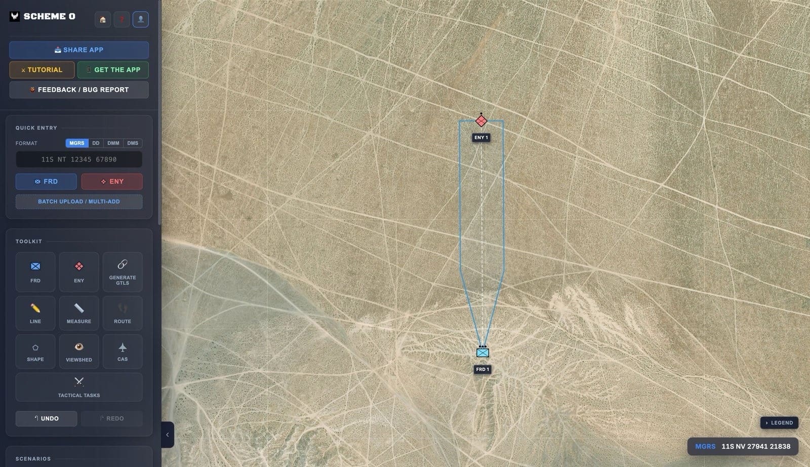
Figure 2. A battlespace geometry generated from three inputs: friendly position, enemy position, and the gun-target line between them. Authors’ screenshot.
Symbology That Reads Correctly
The operational terms and graphics catalog is drawn from exact MIL-STD-2525 assets rather than from shapes improvised to look close enough, so every friendly, enemy, weapon-system, and control-measure symbol carries the right frame, affiliation, and echelon. Nobody should be hunting for a symbol or building one out of triangles at 2200.
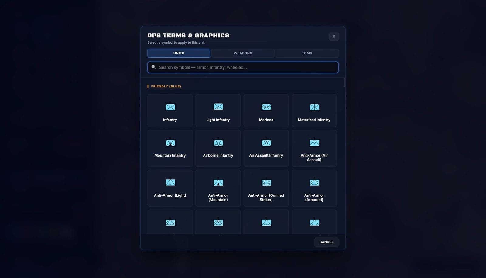
Figure 3. The operational terms and graphics catalog, built on exact MIL-STD-2525 symbology. Authors’ screenshot.
Lines, Control Measures, and a Tape Measure
Phase lines generate off a northing or snap to exact grids when they must match guidance from higher. Boundaries, multi-point lines for enemy obstacles, and shapes that define engagement areas or range limits take a few clicks and produce grids for every point, which makes them easy to read back during a confirmation brief. To quickly measure, hit the measure tool, select any two points and the tool returns distance and direction without anyone reaching for a protractor.
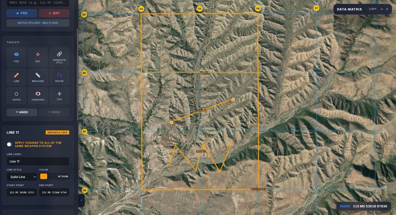
Figure 4. Lines, boundaries, and shapes, drawn quickly or snapped to exact grids. Authors’ screenshot.
Routes and Time-Space Analysis
Trace a route by clicking along the desired path and Scheme O assembles it in real time: waypoints land on their own, checkpoints take a single click, and the numbering sequences itself. Every leg reports grid and magnetic azimuths and distance in meters, feet, kilometers, or miles. Enter a pace and a start time and the tool returns total movement time and an ETA at every checkpoint. Or work the problem backward: give it a no-later-than time and Scheme O calculates the pace required to make the timeline, with a departure time to match.
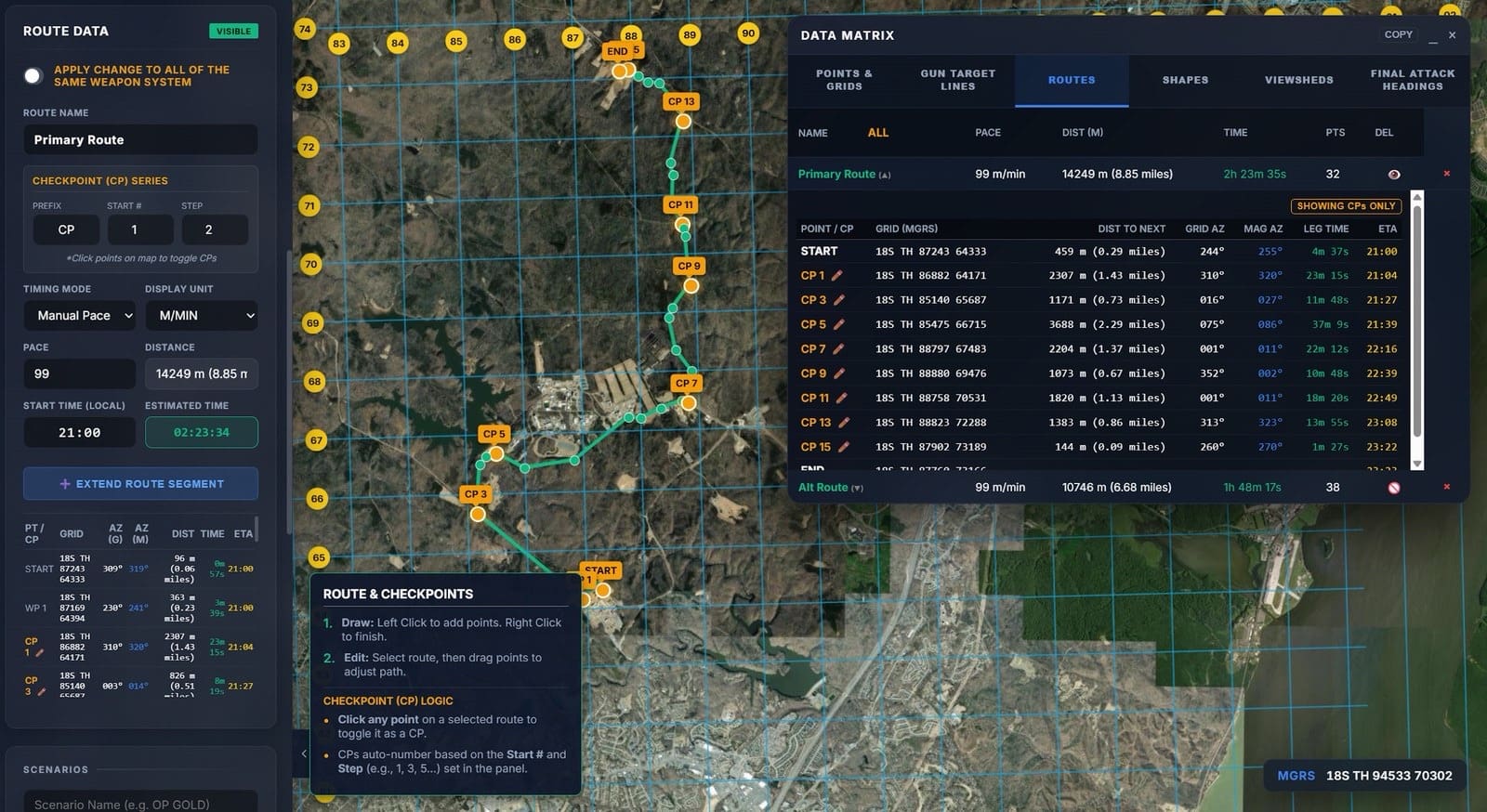
Figure 5. Route planning with automatic checkpoint sequencing, per-leg grid and magnetic azimuths, and time-space analysis. Authors’ screenshot.
Seeing the Terrain Before You Walk It
Viewshed analysis runs from any position at a specified observation height and returns what that position can see and what it cannot. Range rings tie to a symbol on the map, so the threat’s observation and fields of fire appears the moment the enemy picture does, and engagement areas stop being a matter of argument.
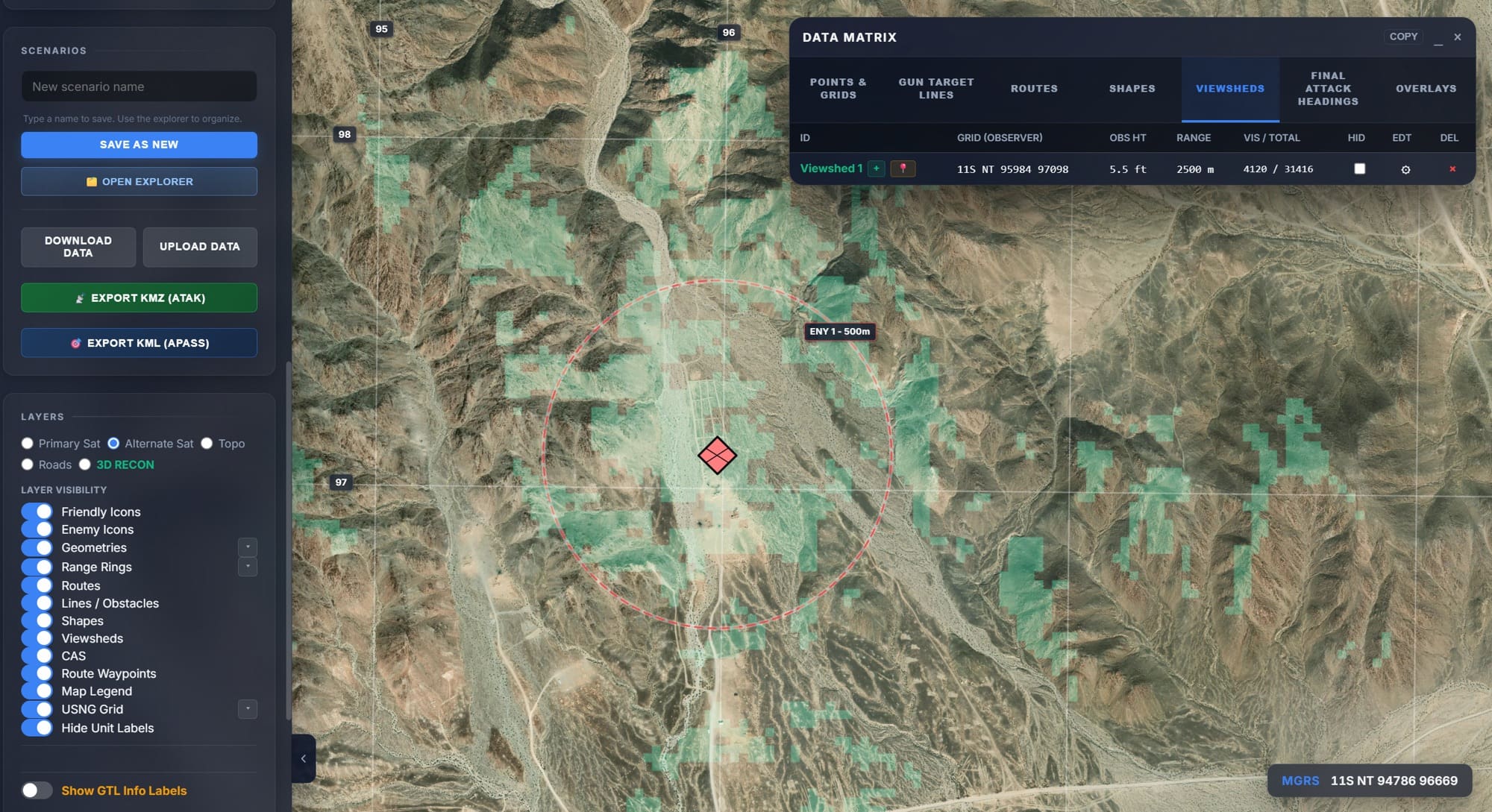
Figure 6. Viewshed analysis and a range ring generated from an enemy position, showing observation and dead space. Authors’ screenshot.
There is also a three-dimensional terrain mode, which is the feature our platoon commanders use most for a rehearsal.
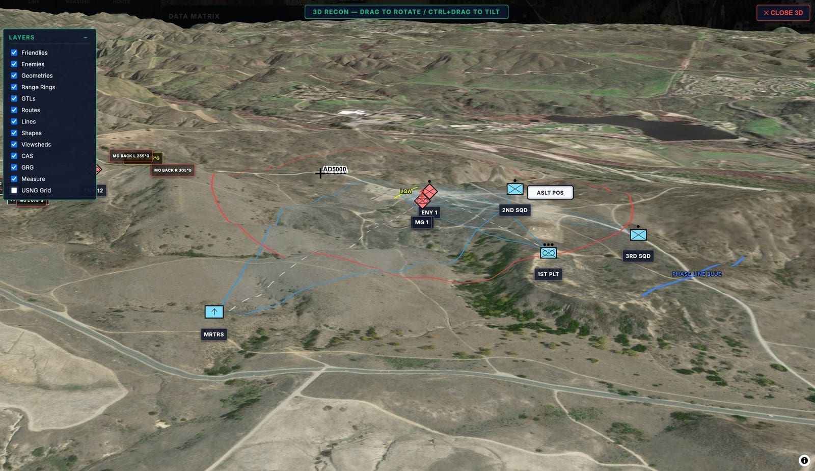
Figure 7. Three-dimensional terrain mode, used to study how a plan sits on the ground before anyone steps off. Authors’ screenshot.
Fires and Close Air Support
Select an enemy position and the tool generates final attack headings, their reciprocals, maneuver buffers, and minimum safe distance rings. All of it is adjustable in length and visual weight.
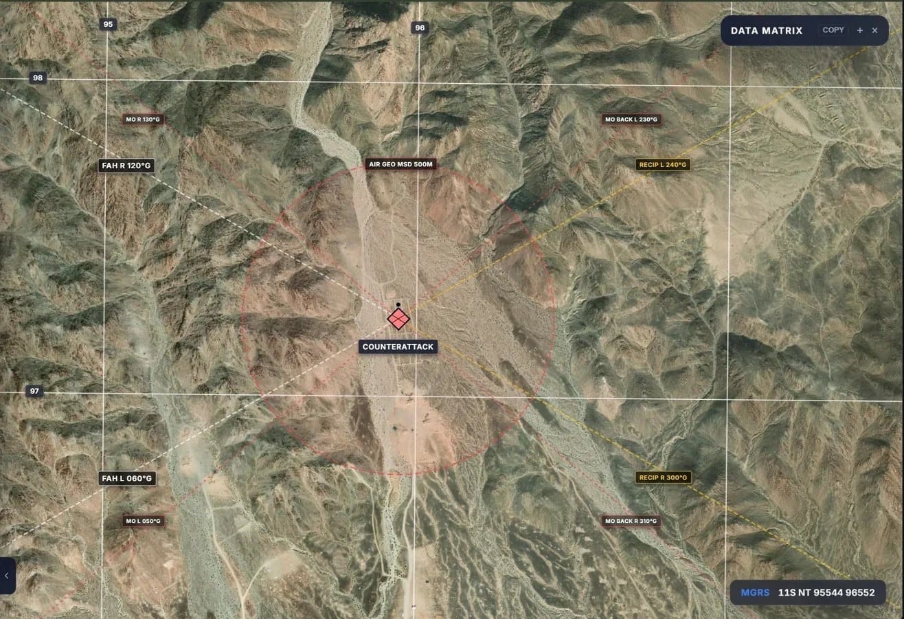
Figure 8. Final attack headings, reciprocals, and a minimum safe distance ring generated off an enemy position. Authors’ screenshot.
From the Map to the Order
A data matrix consolidates every position, grid, route, and geometry in the plan into text that can be pasted directly into an operation order or PowerPoint brief. Instead of spending hours on meticulous manual measurements and transcription, platoon commanders can focus on whether their tactical decisions are sound. A growing set of templates also pulls weather, illumination, first and last light, etc., into a format that drops directly into the orientation paragraph.
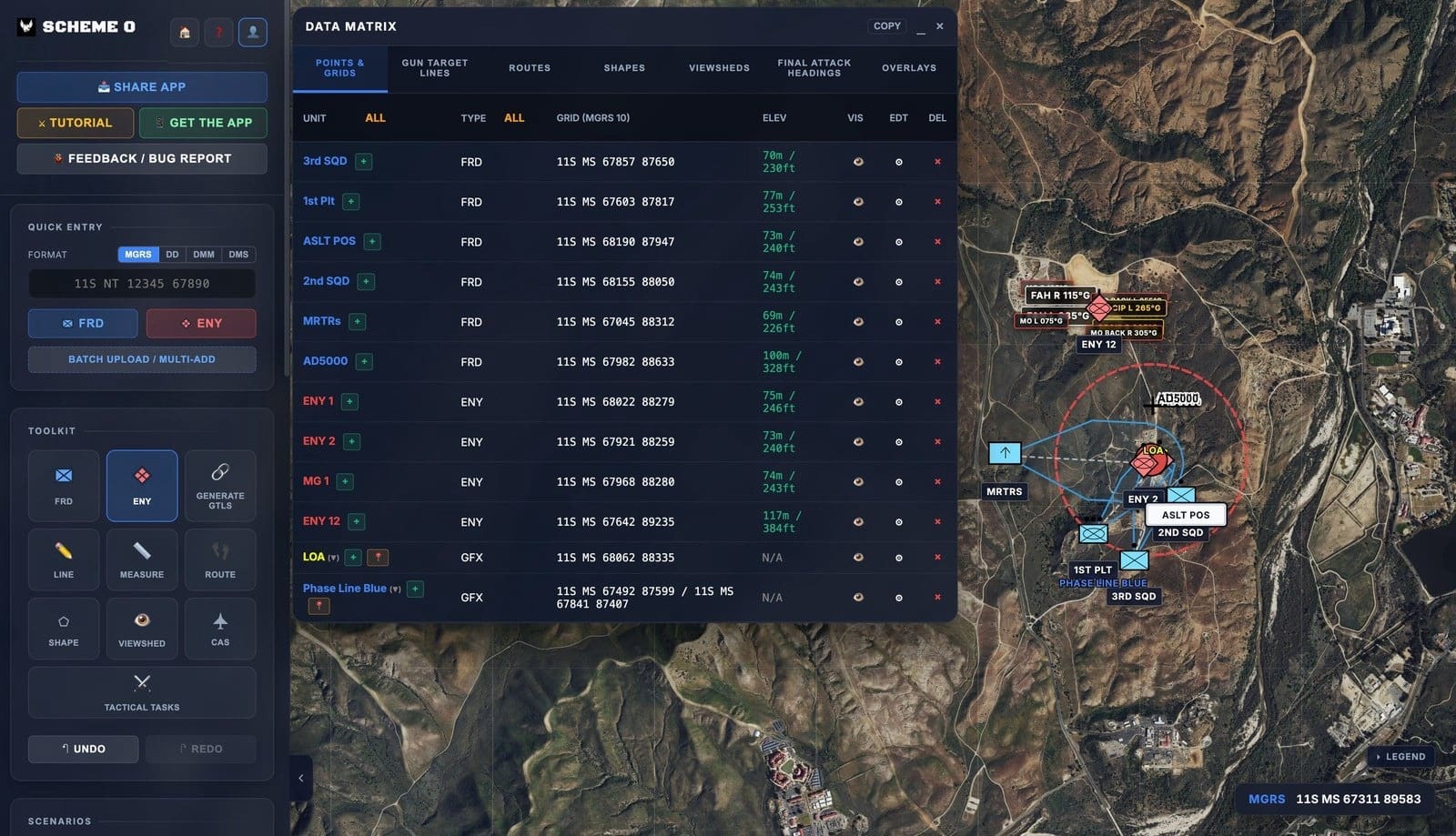
Figure 9. The data matrix, which collects every position, grid, route, and geometry into text that can be pasted into an operation order. Authors’ screenshot.
Products That Survive a Change of Plan
The plan can also be exported to PowerPoint as individually movable objects rather than a single flat screenshot. We built this feature after Lt Bergstrom and I spent far too many hours rebuilding slide after slide for briefs to the MEU whenever the plan changed.
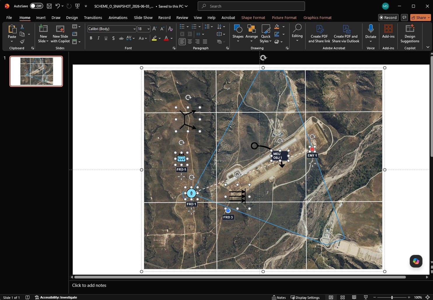
Figure 10. The same plan exported to presentation software, where each symbol, route, and control measure remains a separate movable object. Authors’ screenshot.
Two Evolutions, Reported Honestly
We first used Scheme O as a company during PHIBRON-MEU Integration Training, where compressed shipboard timelines made it an honest test of the workflow. In previous evolutions, company- and platoon-level planning required hours of manual measurements, handwritten grids, individually constructed geometries, and slides rebuilt whenever the plan changed.
With Scheme O, the company and platoons worked from the same planning picture. Geometries were generated, grids populated, and briefing products exported rather than rebuilt. Both levels recovered several hours for enemy analysis, tactical refinement, rehearsal, and—most importantly—preparing the Marines who would execute the plan.
We used the platform again during the Amphibious Ready Group/Marine Expeditionary Unit Exercise, and the result held. The company and platoons again recovered several hours, while receiving updated planning products earlier and avoiding the need to recreate work already completed at another level.
The exercise also revealed two uses we had not anticipated. Amphibious Combat Vehicle sections used Scheme O to coordinate a boat lane with the ship through a shared picture with headings and distances already calculated. We also used its overlays for an interactive tactical decision game, allowing leaders to build, share, and compare schemes of maneuver on the same terrain.
Conclusion
The joint force is right to invest in speed and advantage at its highest levels. But modernization should also reach the company and platoon leaders who translate those decisions into action. At their level, the greatest opportunity may be better tools for the routine frictions of planning—the measurements, graphics, calculations, and products that consume time.
The fundamentals must remain. Leaders should know how to plan with a map, compass, and protractor when conditions require it. But the mastery of those skills should provide a foundation, not impose a permanent workflow. The next step is to measure where time is being lost, listen to the practitioners closest to the problem, and give them the freedom to adopt better tools. Every hour recovered from the friction which the current mechanics of planning produce is another hour returned to analysis, rehearsal, and most important, the Marines and Soldiers preparing to execute the mission.
Disclosure and Disclaimer
Conflict of interest: the authors created Scheme O and hold a financial interest in the company that develops it. They received no compensation for this article, and no government entity has endorsed, procured, or sponsored the platform.
The opinions expressed here are the authors’ alone and do not reflect the views of the Department of War, the United States Marine Corps, the United States Army, or any other government entity. Scheme O is a privately developed tool and is not an official system of, endorsed by, or affiliated with any government entity. All figures are the authors’ own screenshots of software they built, taken on unclassified training data, and contain no controlled unclassified information.
Both comments and pings are currently closed.
Read the full article here
