In an era where unmanned aerial systems (UAS) are pivotal in modern conflicts, the ability to navigate effectively in GPS-denied environments has become a critical requirement. Precise navigation is not only important for flying out and returning safely, but for arriving and observing points of interest with onboard sensors. Without drift-free navigation, a platform will end up arriving at the wrong point and observing the wrong area.
At OKSI, we’ve developed OMNInav, a cutting-edge solution that delivers precise and reliable navigation without relying on GPS by combining multiple navigation techniques to maximize performance across a wide range of environments and scenarios. This article highlights the innovative features of OMNInav and its role in addressing the challenges of modern UAS missions. It also highlights its robustness to various environmental and geographical problems sets where most other solutions struggle.
Overview of OMNInav
OMNInav is a core component of the Omniscience drone autonomy framework, delivering precise, real-time, multi-modality positional awareness to enable autonomous operations in GPS-denied environments. By integrating seamlessly with popular flight stacks like PX4, ArduPilot, and custom variants, OMNInav replaces GPS input, allowing the autopilot to handle navigation with accurate positional data. It supports a wide range of unmanned airframes, including rotary, fixed-wing, and VTOL aircraft.
Key Features:
- Modular Design: Seamless integration with existing UAS hardware and software systems.
- Modular Software Solution: Accelerated containerized software solution ready to deploy on your systems existing companion computer.
- COTS and Custom Hardware Available: Low SWaP, 70x50x50 mm, weighing 300 grams, and as low as 5 watts of power. Day & Night capable with LWIR camera option.
- Advanced AI Models: Highly trained AI-based satellite registration models for cross-modality navigation, supporting visible and infrared imagers.
- Flexible Deployment: Available as a software-only solution or combined hardware and software package.
Understanding GPS-Denied Navigation Methods: Explaining the Weaknesses of Single-Modality Solutions
OMNInav addresses limitations in traditional GPS-denied navigation methods by integrating multiple advanced techniques. Below is a detailed overview of commonly used visual navigation methods and their drawbacks.
1. Optical Flow
- Definition: Tracks pixel motion in an image stream to estimate relative velocity.
- Advantages: Computationally efficient and simple to implement.
- Drawbacks: Does not perform well at higher altitudes and in settings with rapid motion. Usually requires the use of a laser altimeter to properly scale state estimates.
- Real-World Example: A drone navigates a smoke-covered battlefield and cannot rely on optical flow alone due to obscured visuals and erratic movement caused by explosions or turbulence. Sending out laser altimeter energy to get altitude information gives away the drone’s position.
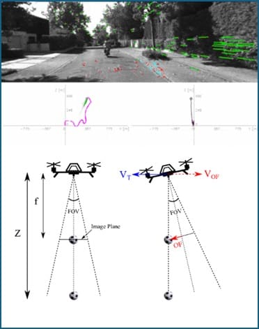
Figure 1: Illustration of optical flow in UAS navigation. (1) a real-world scene from the UAS camera with overlayed optical flow vectors, (2) a plot representing optical flow data, and (3) a diagram showing how the UAS’s field of view (FOV) changes with tilt angles.
2. Visual Inertial Odometry (VIO)
- Definition: Combines camera and inertial sensor data to estimate motion and position.
- Advantages: Reduced drift compared to optical flow alone.
- Drawbacks: VIO can struggle with scale inaccuracies during initialization and is more difficult to implement reliably due to it needing highly synchronized inertial data.
- Real-World Example: A drone flies to a target using only software synchronized camera and inertial data, leading to low-accuracy scale estimation and missing the target by several hundred meters.
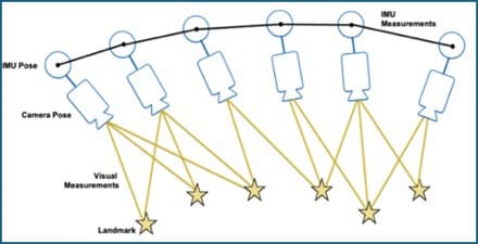
Figure 2: Depiction of Visual-Inertial Odometry (VIO). The image illustrates how a UAS combines data from its camera (camera pose and visual measurements) with inertial measurements from the IMU (inertial measurement unit).
3. Simultaneous Localization and Mapping (SLAM)
- Definition: Builds a map of the environment while simultaneously localizing the vehicle’s position within the map.
- Advantages: Provides accurate navigation when flying locally in areas without a prior map.
- Drawbacks: More computationally demanding in terms of compute and memory to store a live map.
- Real-World Example: A drone flies several low-altitude orbits over various compounds and can re-localize itself when revisiting a prior orbit. The additional compute and memory requirements means the drone has a more capable offboard processor in addition to the flight controller.
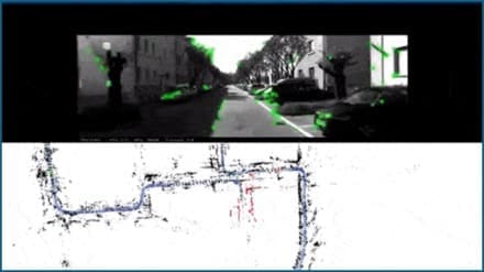
Figure 3: Simultaneous Localization and Mapping (SLAM) in action. The top panel shows a UAS’s camera view with detected visual features highlighted in green, while the bottom panel illustrates a real-time map of the environment generated by the SLAM algorithm. The map includes key structural features and demonstrates loop closure.
4. Feature-Based Localization
- Definition: Uses pre-stored satellite maps to determine absolute position and correct drift.
- Advantages: Provides robust, drift-free global positioning.
- Drawbacks: Requires maps to be loaded to the vehicle. Provides lower frequency updates and holes in areas where no matches can be found.
- Real-World Example: A drone transits a long very distance and resets its drift as it flies to arrive at the target with very low error, letting it observe the point of interest autonomously without a pilot fixing the camera.
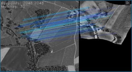
Figure 4: Example of OMNInav’s map-based feature matching for position correction and drift reset. The image illustrates a UAS using feature matching to align its live LWIR camera data (left) with a pre-stored visible map (right).
5. Military-Grade Navigation Systems
- Definition: Advanced systems used in military applications, often leveraging custom hardware and complex algorithms.
- Advantages: Highly accurate and reliable in GPS-denied environments.
- Drawbacks: These systems are prohibitively expensive, bulky, and often proprietary, making them unsuitable for broader commercial applications or cost-sensitive defense missions.
- Real-World Example: High-end inertial navigation systems (INS) used in military drones provide reliable navigation in GPS-jammed environments but require extensive calibration and are not viable for smaller, lower-budget UAS operations.
OMNInav’s Innovative and Multi-Modality Approach
OMNInav bridges the technology gaps of traditional navigation methods by combining multiple advanced techniques into a unified, multi-modal system. By integrating SLAM for models trained on large-scale satellite imagery datasets for global localization, and robust sensor fusion, OMNInav eliminates the weaknesses of single-method approaches. This innovative design ensures drift-free, accurate navigation across diverse flight profiles, making it ideal for both commercial and defense applications.
Key Features:
- SLAM for Precise Local Navigation: Creates detailed maps and tracks positions in real-time, providing high frequency positional updates.
- AI-Based Feature Matching for Global Localization: Provides state-of-the-art, zero-shot global localization by matching observed features to stored datasets and then backing out absolute position to reset drift.
- Robust Sensor Fusion for Optimal Performance: Calibrates and fuses all available onboard sensors such as airspeed, inertial, and more to provide optimal positional estimates.
Addressing Real-World Challenges
OMNInav’s capabilities excel in overcoming the toughest navigation challenges in GPS-denied environments:
1. Low-Light and Night Operations
Trained on visible and infrared imagery, OMNInav ensures reliable navigation regardless of lighting conditions, camera modality, and map type.
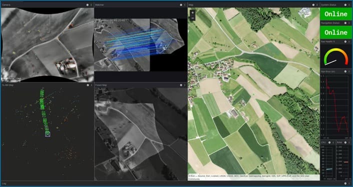
Figure 5. OMNInav’s agnostic modality capability performing with high accuracy in complex repeating pattern farmland.
2. Seasonal and Environmental Changes
Handles vegetation growth, snow cover, and landscape alterations using its robust AI models trained on multi-year satellite imagery.
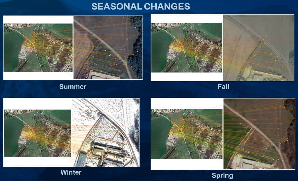
Figure 6. OMNInav is robust, handling seasonal variations from lush greenery to snow-covered terrain.
3. Man-Made Environmental Transformations
Adapts to rapidly changing environments such as construction zones and areas of conflict, ensuring robust navigation accuracy even with very old imagery. OMNInav has been tested with imagery up to 10 years old successfully even with large-scale map differences.
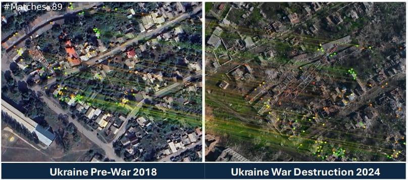
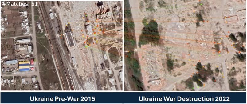
Figure 7. OMNInav accurately registers navigation points despite extensive urban damage.
Competitive Advantage
OMNInav’s unique multi-modal design ensures it outperforms competitors in GPS-denied environments by:
- Surpassing Single-Method Systems: Combines SLAM and AI-driven feature matching to overcome the limitations of traditional approaches like optical flow, VIO, or basic feature-based localization in isolation.
- Cost-Effective Alternative to Military-Grade Systems: Offers military-grade reliability without the prohibitive costs, bulks, or calibration demands of high-end inertial navigation systems.
- Excelling in GPS-Spoofing Scenarios: Fully bypasses GPS reliance, making it indispensable in regions like Ukraine where GPS spoofing and jamming are prevalent.
A Game-Changer in Drone Navigation
OMNInav is redefining the standards for GPS-denied navigation with:
- Seamless integration into existing systems
- Superior adaptability to environmental changes
- Industry-leading accuracy in autonomous operations
To further enhance UAS capabilities, OKSI also offers OMNIlocate, a solution for high-accuracy (CAT I/II) target localization using standard gimbaled sensors. Enabling air platforms to derive high accuracy target position without using GPS.
Ready to take your unmanned systems to the next level?
Discover how the OMNISCIENCE suite can revolutionize your operations with advanced, modular solutions for GPS-denied navigation, tracking, target geolocation, and more. Whether you’re planning complex missions or navigating challenging terrains, OKSI has the tailored tools you need. Explore the full range of OMNISCIENCE modules and cutting-edge technologies from OKSI. Learn more and watch our video series to see how we’re redefining drone autonomy for both defense and commercial applications.
Contact Us
Email: [email protected]
Website: www.oksi.ai/contact
Learn more: www.oksi.ai/omniscience
Both comments and pings are currently closed.
Read the full article here







Leave a Reply